


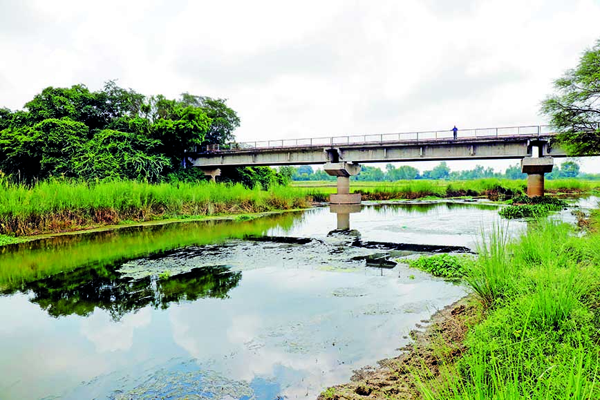
The Gomti river at Kudia Ghat in Lucknow
Can Lucknow get back its rivers and lakes?
By Venkatesh Dutta
THE city of Lucknow is planning a revival of its water heritage. If the effort succeeds at least one shrunken river with wetlands, lakes and rivulets could gradually spring back to life over time.
Originally, the city depended on waterbodies for its survival. Thoughtless urbanization then tore this harmonious equation apart. Restoring it, in some measure, will be key to survival and a sustainable future.
The rapid growth of Lucknow calls for a course correction. As the population has risen, housing needs have multiplied. There has been a building boom — both formal and unorganized. Neither has been regulated with a vision for a healthy future.
Construction has happened on floodplains and wetlands have been gobbled up. With natural sources of water either gone or polluted, Lucknow could face a serious water crisis. Residents are already relying on deep borewells with the rapid decline of the groundwater table across the city.
In addition, global warming has brought uncertainties. There are long dry spells and then so much rain that the city is flooded. A healthy river system could solve both problems by being a source of supply and a receptacle for the run-off during the monsoon months.
The Gomti, which runs through Lucknow, has been under stress. The Kukrail, that joins it in the middle of the city, has been reduced to a drain. Rejuvenating the two rivers is important but simultaneously their catchments and networks of smaller waterbodies have to be revived and protected.
In May, Uttar Pradesh Chief Minister Yogi Adityanath convened a meeting for rejuvenating the Kukrail. The CM asked officials to conduct a comprehensive study on improving the river’s water flow.
In response, our team of researchers conducted a survey of the entire river stretch and presented a revival report within 15 days. We have been working on the restoration of the Gomti and its tributaries since 2005.
In 2011, I undertook a 960-km yatra along the Gomti and documented more than 60 tributaries of the river. This led to the initiation of rejuvenation programmes of smaller rivers in the state. Nature-based solutions are best for rejuvenating rivers.
The 28-km Kukrail is an important tributary of the Gomti. It originates from Asti village of Mahona and winds its way through the Kukrail forest, converging with the Gomti near a barrage.
The Kukrail forest survives due to this river. Just like the Gomti, the Kukrail is fed by artesian wells and springs. North Lucknow was drained by the Kukrail river while the southern part of the city was drained by the Sai river. The two rivers were further fed by many streams. Sadly, as Lucknow grew, no attention was paid to these water sources.
Before the construction of an embankment in 1962, the Kukrail river joined the Gomti downstream of the barrage opposite Martinpurwa. However, following the construction of the embankment, this section of the river became isolated from the mainstream flow.

The area between the Kukrail and the Gomti used to be known as the Municipal Sullage Farm. It was owned by the municipal corporation. In 1980, this area was transferred to the Lucknow Development Authority (LDA) for residential and commercial development.
Renowned for its purity, the water of the Kukrail was lauded in the British Gazetteer. Initially, groundwater played a significant role in sustaining the Kukrail’s flow. However, due to a substantial decline in the groundwater table, the base flow has diminished considerably, nearly ceasing the natural flow of the river.
PROTECTING FLOODPLAINS
The state government is planning to revive the flow of the Kukrail from its point of origin in Asti village where it has been reduced to a mere trickle. The first step is to return the floodplains to the river.
The Sub-Divisional Magistrate of Bakshi ka Talab block of Lucknow has received directives to swiftly remove all encroachments along the banks of the Kukrail. The official was instructed to collaborate with the revenue department to ensure clearance of the area.
The Chief Development Officer of Lucknow has been entrusted with the responsibility of supervising the restoration of 22 ponds scattered across Asti village. These ponds will eventually serve as feeders for the Kukrail, improving its water flow in future. The drainage of the catchment area from where the Kukrail originates is impeded by the construction of Kisan Path, a ring road that circumscribes Lucknow.
 The southern part of the city is drained by the Sai river
There is an urgent need to undertake notification of waterbodies and take strict measures against encroachment. If these waterbodies are not saved, the entire settlement of Lucknow will face dire consequences. Lucknow had many waterbodies, tals, lakes, wetlands and rivers. It had excellent drainage.
We have mapped each and every stream and wetland of Lucknow, using high-resolution satellite pictures. We are also using drone cameras to study the extent of waterbodies.
Lucknow boasts 1,370 wetlands even today which we have identified through satellite remote sensing. Around 108 have now been earmarked for restoration.
Waterbodies are our natural heritage. They came into existence millions of years ago. They are sanctuaries, just like forests, and should be protected. The status of waterbodies must be mapped every year, just like forests.
Lucknow is famous for its gardens. But it was also once famous for its lakes and ponds. Historical records document hundreds of waterbodies, varying in size, scattered throughout the district.
Interestingly, most waterbodies were interconnected with the Gomti river and its numerous tributaries, ensuring a steady water supply to the river year-round. Given that the Gomti is sustained by groundwater, its feeder streams, lakes, and ponds hold significant importance as they contribute to its perennial flow. Many of these rivers survive even today and could serve as vital parts of the city’s drainage system.
Unfortunately, some have been converted into sewage-carrying drains, while others have fallen victim to extensive encroachment by private and government entities. There are no legal provisions in place to safeguard the land adjacent to these waterbodies. In numerous instances, roads and buildings have been constructed directly on riverbanks, constricting the natural flow of the water.
In Hulaskheda of Mohanlalganj in south Lucknow lies a large oxbow lake, known as Karela Jhil. It is situated around an excavation site that dates back to the Bronze Age. This lake, once a segment of a flowing river, played a vital role in early human settlements, serving as a water source for over a dozen villages.
Karela Jhil overlooks a series of lakes to the southeast, extending up to Nagram. At its western extremity flowed the Bakh river, which used to irrigate thousands of acres of agricultural land. Today, local people do not even know that a Bakh river existed here just 50 years ago!
During the late 1980s and 1990s, numerous colonies came up on the wetlands and floodplains of such rivers, rivulets, and natural streams, causing irreversible harm to these vital ecosystems, which are otherwise protected under the law.
Consequently, groundwater levels in the city have been steadily declining by one metre annually, due to the loss of natural recharge sites. Public properties of revenue villages, such as nullahs, ponds, chak roads and pastures, were sold to builders and land development agencies. The development authorities even came up with colonies on large ponds, resulting in the disappearance of 70 percent of ponds over the past four decades.
FORESTS, RIVERS, LAKES
Forests, rivers and lakes were seamlessly connected. There is a record of dense dhak forests around the areas of Mahona, Mal, and Malihabad in Lucknow at the beginning of the 20th century. The Gomti, along with its three tributaries — Behta, Jhingi and Akraddi — meandered through these wooded landscapes in the north. The Behta originated from lakes nestled in the eastern centre of Sandila in neighbouring Hardoi district, traversing into Lucknow through the forests of Malihabad.
And tigers frequently travelled from Lakhimpur Kheri and Hardoi to Lucknow, drawn by the watercourses along these routes.
Waters from the northern part of Kakori contributed to the flow of the Behta river. Ultimately, the Behta converged with the Gomti in Kankarabad village. Approximately 80 percent of Mahona’s fields were nourished by ponds and lakes. Green fodder was transported via boats from Mahona to Lucknow through the Gomti.
Such was the abundance of water that groundwater would appear just 16 to 20 feet below the surface. The villages of Ataria and Manjhi in Malihabad were situated in the khadar (floodplain) of the Gomti and were prone to frequent flooding.
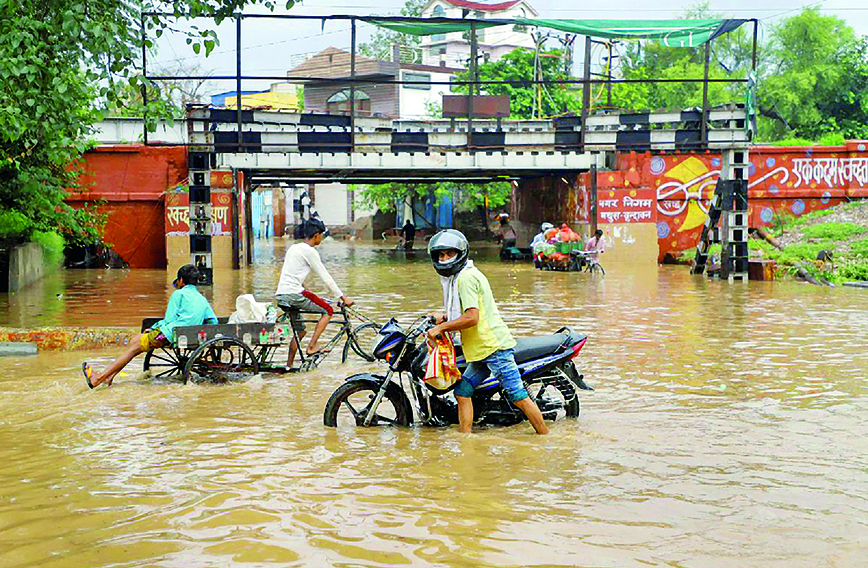 Encroachments on river floodplains, destruction of ponds and wetlands are leading to urban flooding
In the northeastern part of Lucknow, numerous lakes nestled amidst dense dhak forests. The Reth river originated from the marshy woodland near Gulariya at the northeastern tip of Mahona. These lakes collectively contributed their waters to the Reth river, which, after meandering a short distance within Lucknow, progressed into Barabanki district, a bit farther to the east.
Sadly, all these lakes have been encroached upon by numerous housing projects.
In the southwest corner of Lucknow, the Sai river enters through Mohan, delineating the boundary between Unnao district and south Lucknow. One side of the river belongs to Unnao, while the other side is within Lucknow. Many lakes and ponds in Mohanlalganj were consistently brimming with water.
The Jalvihar Utsav (water festival) was celebrated here during August-September with elaborate boating and musical performances on the rivers and ponds. On the northern and eastern perimeters of Sisendi, several sizeable lakes irrigated the fields of the village. A forest spanning approximately 270 acres also adorned this village.
The Bakh river originally sprang from the cantonment area behind the Lucknow Railway Station. Initially, it was sustained by water from numerous lakes, forming an extensive chain of large bodies of water near its source, which eventually transformed into a perennial stream.
Subsequently, settlements such as Aashiyana, Bangla Bazaar, and LDA colonies came up on these lakes. One of the feeder lakes to this river was Qila Mohammadi lake in Aashiyana, contributing to its flow. Over time, the Bakh metamorphosed into the Qila Mohammadi drain.
As a tributary of the Sai river, the Bakh meandered for 56 km in southern Lucknow before converging with the Sai. The water from Haibatmau lake, adjacent to the Rae Bareli road, used to flow into the Bakh river. However, establishment of the Vrindavan Colony and Eldeco Colony two decades ago led to cessation of water flow into Haibatmau lake. Many unplanned private settlements also came up around the Haibatmau lake. What we see now is not even 10 percent of its original size.
Originating in Unnao district, north of Mohan, which acts as a demarcation between Kakori and Mohan, the Nagwa river briefly marked the border between Kakori and Bijnor before entering Bhadoi in Bijnor. The Nagwa river receives water from the southwestern part of Kakori. After a brief journey, it flows into Bijnor and eventually merges with the Sai near Bani.
Notably, the expansive Chande Baba Taal, situated in Garhi-Chunauti, a site of religious significance in Sarojini Nagar, covered an area of approximately 200 acres. The water from this lake fed into the Nagwa river. The Nagwa has now been reduced to a small channel receiving sewage and wastes from housing settlements and industries.
The Loni river originates in the northeast of Mohanlalganj tehsil of Lucknow and joins the Gomti near Salempur. This river played a crucial role in irrigation in Mohanlalganj. It is now reduced to being just a small drain.
WHAT CAN BE DONE
The end-of-pipe solution is an outdated idea. We should learn from our past mistakes. The world is moving away from large-scale centrallized STPs. These require huge capital expense for pumping and treatment. Besides, the water they eventually produce is never up to the mark. It is far better to treat water at source through small, decentralized STPs and use the water to restore the ecosystem or for other purposes. Water should be used, reused and returned to nature.
No human, machine or technology is superior to the intelligence of nature. River rejuvenation should be based on revitalizing river processes through nature-based solutions. Unfortunately, in many projects cosmetic treatment is done with irreparable damage to the river ecology.
The second issue is encroachments. Decisions on urban growth and governance have consistently overlooked encroachments on river floodplains, resulting in destruction of ponds, wetlands, and interconnected water systems.
Consequently, our cities are experiencing frequent and severe flooding due to the removal of these natural absorbers and the subsequent reduction in the rivers’ flood-carrying capacity. It is crucial for urban planning policies to prioritize the protection and restoration of river floodplains, wetlands, ponds and waterbodies for more water in summer and less flooding during the monsoon.
The riverfront should be known for its naturalness. It should have minimal use of concrete. Remember, this area will flood during high-intensity rain. If you reduce the width of the floodplains or the riverbed, you put communities at higher risk of flooding.
The age of these rivers is in millions of years, whereas your concrete infrastructure will not last even five decades. Therefore, you threaten the resilience of the river. This has a cascading impact on the health of the river and our own survival.
Just like the river channel, the land adjacent to it on both sides is important. If you lose the river terrace, you lose the river. The riverbanks store water and recharge aquifers very fast. The banks should be natural with native plants and grasses. This foliage is the refuge of a variety of life forms. If you take away riverbanks and replace it with concrete walls, you destroy all the processes which keep the rivers alive.
Venkatesh Dutta is a Gomti River Waterkeeper and a professor of environmental sciences at Ambedkar University, Lucknow.
Comments
-

Chandralekha Anand Sio - Aug. 10, 2024, 8:11 p.m.
An informative and interesting article.Gives knowledge of so much we don't know.