


VENKATESH DUTTA
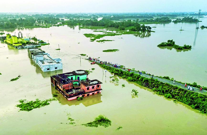
LAST month in Bihar many rivers swelled, spilling onto floodplains and inundating farms, settlements and roads, and displacing more than two million people. Due to very heavy rains between September 27 and 28 in Nepal, a high volume of water suddenly entered the Kosi, Gandak, and Bagmati rivers on September 28.
Within 24 hours, embankment breaches along the Indo-Nepal border in several blocks led to severe flooding, affecting large settlements. All major transboundary rivers in Bihar such as the Kosi, Bagmati, Mahananda, Parman, Kamla, Adhwara, Gandak and the Burhi Gandak were in spate. The flood situation worsened in the first week of October as floodwaters entered new areas.
Approximately 28.69 lakh people were affected by floods across 450 villages. About 13.70 lakh were children. On September 30, 67 blocks across 13 districts were severely affected including the high-density areas of Sitamarhi, Patna, Katihar, Purnea and Bhagalpur. This time, the rivers flowed above the embankments at several places, indicating that their beds had been choked with silt due to jacketing by embankments on both sides. The sediments are being confined inside the two sides of the river for decades, making it shallower. The irony of facing extensive flooding, alongside a 20 percent rainfall deficit in the state, paints a complex picture of how climate patterns and water management are interacting.
When a river overspills its banks, flooding happens. During a flooding event, the volume of water in a river becomes so large that it covers areas outside its own channel. The textbook definition of a flood is “an unusually high stage in a river — normally the level at which the river overflows its banks and inundates the adjoining area”.
The annual inundation of floodplains by incoming water is a normal event. The water flows downstream, carrying with it large amounts of sediment. This is how the Ganga delta came up, through a large built-up of sediments carried by the rivers. The rivers in the Ganga Basin are high-energy systems — they transform landscapes, recharge aquifers, carry high sediments and replenish ecosystems. The Indo-Gangetic-Brahmaputra plains in north and northeast India are among the most flood-prone areas on earth. These basins carry almost 60 percent of India’s total river flow.
The monsoon system is very old —15 million to 17 million years old. Nature has designed it in such a way that 75 percent of rain occurs in just four months — between June and September. Out of these four months, the peak spell is of 15 to 18 days — when the river swells with heavy discharge. We are supposed to plan for this three-week mayhem which is ‘climatically natural’ for the rivers. Water will return to where it belongs, in river valleys, old channels, natural depressions and so on. But if we block rivers, the flooding impact would be manifold.
Bihar has a unique geomorphological setting — the northern part is drained by extensive river networks coming down from the Himalayas and merging into the Ganga. From the high-altitude Himalayas to the almost flat plains of north Bihar, rivers with heavy discharge get a short distance and time span to travel.
Several rivers are transboundary. They enter Bihar from Nepal, arriving rather quickly from high mountains and carrying a large volume of water, unconcerned about administrative boundaries. This is how rivers travel from upstream to downstream. They also carry sediment loads from the slopes of the Himalayas. Rivers often change their course due to shallower and flat channels and soft alluvial soil. Due to the shift of the river channel and heavy bank erosion, villages on riverbanks get wiped out. The region itself may have a rainfall deficit. Yet, when floodwaters from upstream regions make their way downstream, it leads to flooding even when local rainfall is sparse.
About 73 percent of land in Bihar is flood-prone. This means 30 out of 37 districts have around 22 percent of the country’s flood-affected population. What is really worrying is that Bihar’s flood-prone area has nearly tripled from 2.5 million hectares in 1954 to 6.8 million hectares in 2024. This shows that flood engineering has not been successful in containing these high-energy rivers. Embankments gave only a false sense of relief. They led to drainage congestion and rising of riverbeds.
Before embankments were built, rivers had the option and space to distribute their sediment. Now, rivers quickly overflow their banks. Regular embankment breaches have further compounded the intensity of flooding. The receding of floodwaters from catchments is also obstructed by embankments.
The Kosi embankments were designed to handle a water discharge of 9.5 lakh cusecs, but with the river becoming shallower due to increased sediment deposition, the effective capacity of the river channel to carry water has reduced. This makes the embankments vulnerable to breaching even at discharge levels lower than its design capacity.
The flood-affected people are considered ‘pathological normal’ — they have not been adequately cosseted although they brave the impacts of climate with their own means. Submergence and erosion have become part of their collective psyche and fate. They have been silently going through difficult times, picking up the pieces and starting again, showing immense resilience with locally-led adaptation.
Relief camps are required, but for transformative resilience, long-term floodplain management strategies are needed, that is, strategies that could break the vicious cycle of maladaptation. Taming high-energy and dynamic rivers like the Kosi with dams and barrages is not a good idea.
Venkatesh Dutta is a Gomti River Waterkeeper and a professor of environmental sciences at Ambedkar University, Lucknow
Comments
-

Annapurna - Oct. 26, 2024, 11:24 a.m.
Please discuss extensive flood management strategies