


VENKATESH DUTTA
A few months ago, I travelled to Bahraich district in Uttar Pradesh to carry out a mapping and surveying project of the rivers and water bodies in the area. This district boasts the highest number of water bodies in the state, comprising almost 12 percent of the district’s total geographical area.
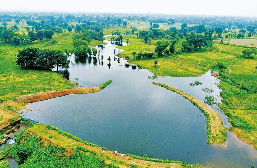
While circumnavigating a particularly large water body named Baghel Taal, whose perimeter stretched almost 42 km, I couldn’t help but notice the numerous farms that had encroached upon its edges, draining the water and colonizing the surrounding wetland areas. This significant wetland offers numerous ecosystem services, serving as a habitat for migratory birds and several aquatic animals, and providing freshwater for human use. However, the large number of encroachments by farms on all sides of the wetland was deeply concerning. The water was drained, and intensive farming was happening around the periphery, threatening this critical natural resource.
I attempted to address this issue by meeting with the chief development officer and the district forest officer of Bahraich. Despite its immense ecological significance, Baghel Taal was not yet classified as a ‘protected wetland’, and its jurisdiction was a subject of confusion between the district forest officer of Bahraich and the forest officials of Katarniaghat, a nearby protected wildlife sanctuary that encompasses several swamps and wetlands. I was deeply disturbed to learn that a water body of such magnitude and importance was still awaiting recognition as a protected area — since it was outside the protected forest.
This situation is not unique to Baghel Taal, but is a widespread issue across many water bodies in our cities and towns where, despite being clearly marked on revenue and satellite maps, they remain vulnerable to exploitation and conversion for housing and commercial development. For land developers and real estate agencies, ponds and lakes are the areas to be filled and converted to housing projects and commercial complexes. This is a disturbing trend and calls for urgent action to ensure that these wetlands are afforded the protection and conservation they so urgently require.
During my survey of wetlands in several districts of UP, I discovered that many water bodies had been leased out by the revenue department to local fishermen and farmers for fisheries and aquaculture. However, as the water levels began to decline, these farmers began to cultivate the wetlands instead. Unfortunately, the leases were never cancelled and in many cases, the land was even sold to property dealers for housing projects. This trend was widespread and I observed it in almost all the wetlands I surveyed.
One particularly egregious example was a 150-hectare wetland called Karela Jheel in Mohanlalganj, located in the southern tehsil of Lucknow, which had been encroached upon by farms and settlements. When the administration was informed of this, they cited law and order problems in removing the large-scale encroachments.
Wetlands are crucial components of our landscape, functioning like the kidneys of our ecosystem — naturally filtering wastes and playing a critical role in maintaining freshwater habitats. These sites serve as biodiversity hotspots, freshwater reserves, carbon sinks, and sources of livelihoods. Additionally, they aid in mitigating the impacts of climate change and extreme weather events. Nature has designed them to store surplus water during rainfall, making them valuable in protecting us from flooding.
They are often undervalued because their ecological services, such as water filtration, habitat provision, and carbon storage, are not easily quantified in monetary terms. Thousands of such water bodies in India are outside the reserved forest or protected areas. They are still waiting to be recognized as protected water bodies. They are easy targets for encroachment. The land development agencies are also not bothered to protect them as these common property resources are sources of money for them.
Even in older revenue maps and satellite imagery, the boundaries of such water bodies are clearly marked. Yet, they remain vulnerable to exploitation by land developers and real estate agents, who see these areas as opportunities for housing projects and commercial complexes. No wonder every year we are losing wetlands by 3 to 4 percent. In the past four decades alone, we have lost almost one-third of wetlands in our country.
The loss of wetlands is a complex issue, influenced by a range of factors including population growth, urbanization, industrialization, and agricultural expansion. In many cases, wetlands are seen as underutilized land whose landuse can be easily converted to farming, housing, and commercial development. Another challenge is the lack of adequate legal protection and enforcement for wetlands. In many cases, wetlands are not recognized as distinct ecosystems in their own right and are instead viewed as wastelands or unproductive areas. This means that they are often left out of conservation planning and management efforts, and are vulnerable to encroachment and degradation.
The Wetlands (Conservation and Management) Rules, 2017 were notified by the Ministry of Environment, Forest and Climate Change (MoEFCC) in September 2017 to safeguard wetlands across India. According to these rules, it was mandatory for all districts to establish a district-level Wetland Authority for the management of wetlands at the local level. A State Wetland Authority was also created to oversee wetland management at the state level. The district magistrate is the chairman of the District Wetland Authority and is responsible for ensuring that no activities leading to wetland destruction take place. The authority has the power to impose penalties for any violations. However, the actual implementation of these rules has been far from satisfactory. In several districts, these authorities have not yet been established, and even in those where they have been, meetings have not taken place.
Accurately mapping all wetlands across the state is a crucial step in the process of restoring them. Proper land records also play a key role. Fortunately, with the help of satellite and drone technologies, creating digital records of wetlands, rivers, and connected water bodies has become much easier.
Venkatesh Dutta is a Gomti River Waterkeeper and a professor of environmental sciences at Ambedkar University, Lucknow
Comments
Currently there are no Comments. Be first to write a comment!