


VENKATESH DUTTA
A river requires sufficient space to carry out its diverse functions. This space is delineated by the river itself, carving out the river valley and the active floodplain over thousands of years, each serving distinct purposes. There is a topographic depression along the course of the river — the river valley.
An obvious question arises: what exactly constitutes the active floodplain of a river, and how do we define it? Typically, this designation relies on hydrological criteria, such as the return period of floods. The flooding zone on both sides of a river is the area necessary to carry the flow of the maximum probable floods. This determines the extent of the active floodplain of a river in a specific stretch. Accurately mapping the width of the active floodplain is essential, as it greatly influences efforts to restore the river’s natural state.
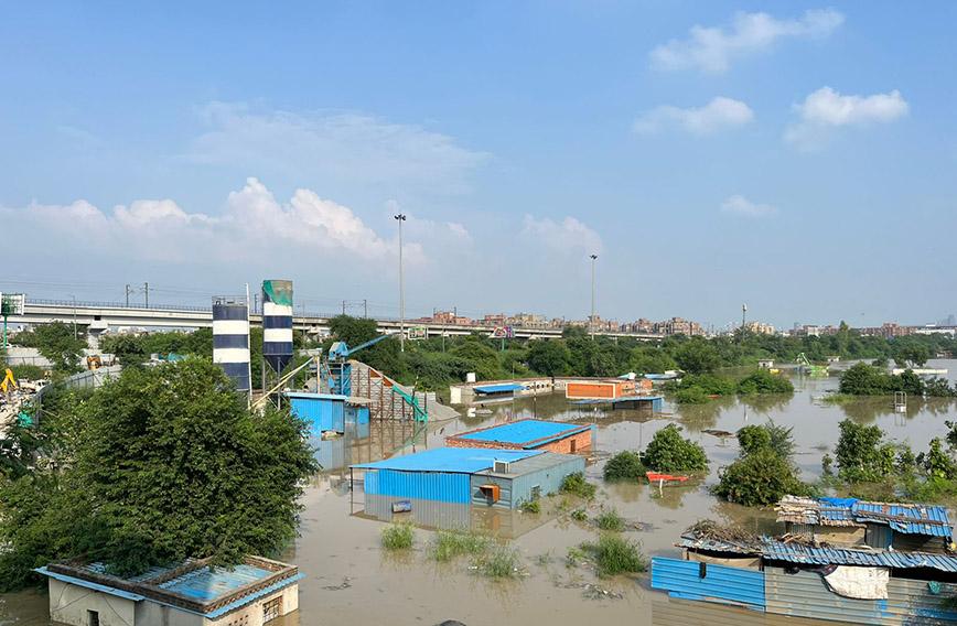
Many historical ghats came up along the rivers in the active floodplain without destroying river ecosystems. Lately, the ghats are being replaced by riverfronts. Many colonies are also coming up on active floodplains. From being a natural space, the river’s terrace gets modified into built-up areas with many residential and commercial establishments.
In April this year, after reviewing a report by the Uttar Pradesh (UP) Irrigation Department on illegal encroachments on the Ganga floodplain in Kanpur, the National Green Tribunal (NGT) noted that the latitude and longitude provided by the Central Water Commission (CWC) for the area had not been designated a ‘No Development Zone’ or ‘No Construction or Regulatory Zone’. In its 2017 judgment on the first phase of marking the Ganga floodplain from Haridwar to Unnao and Kanpur, the NGT stated, “No development or construction work can be undertaken within 100 metres from the banks of the Ganga.”
In a similar case, in March 2024, the NGT directed the UP government to provide a report detailing the measures taken to demarcate floodplain zones along the Varuna and the Assi, which are tributaries of the Ganga in Varanasi. The green panel had responded to a plea alleging that the local civic body had failed to demarcate floodplain zones along these rivers, leading to ongoing encroachment.
Earlier, in May 2013, the NGT had stated that all constructions on the floodplains should be considered unauthorized, with necessary action being initiated against violators. However, despite such clear-cut orders and notifications, the prevalence of the land mafia in grabbing the floodplain is rampant.
A former secretary at the Ministry of Water Resources, River Development, and Ganga Rejuvenation emphasized that encroachments on the floodplains persist despite court orders due to the dishonest intentions of the executive wing. It is evident that such encroachments cannot happen without the collusion of officials and politicians. There is a general tendency of the states not to clearly define floodplain zones and place restrictive signboards stating that encroachment is illegal.
Several permanent constructions had come up on Kukrail river, a 28-km tributary of the Gomti in Lucknow which was earlier referred to as a nala or a city drain by many as it carries sewage from adjacent residential areas. In May 2023, the chief minister instructed officials from various departments and government agencies to prepare a report on the restoration of the Kukrail river.
The Lucknow Development Authority (LDA) issued eviction notices to more than 1,000 residents occupying the terrace of the Kukrail river, pointing out that their structures were built without LDA approval and were located in the flood zone. According to the LDA, the construction was in violation of the master plan and zonal development plan, and without obtaining necessary permissions.
In December 2023, demolition squads razed 58 houses in Bhikampur, and then moved to Akbar Nagar which has around 1,400 houses and 101 shops. But the Lucknow bench of the Allahabad High Court issued a stay order while the appeals from the residents were pending. The court granted an interim stay on demolitions in Akbar Nagar for a month. The matter was slated for hearing once again on January 22, 2024. The court observed that the residents had failed to provide evidence of legal ownership titles. The matter was then transferred from the single bench to a double bench of the Allahabad High Court.
The bench noted that petitioners occupying commercial structures had illegally erected multi-storied showrooms and workshops on extensive parcels of land which were owned by the state government. They were also filing income tax and GST returns, and many resided in residences across Lucknow city while also possessing other properties. In the first week of March 2024, the Allahabad High Court issued an order for residents to evacuate their homes by midnight on March 31. The court also directed the state government to ensure that all residents being relocated from Akbar Nagar slums were provided housing.
After this order, residents lodged three special leave petitions (SLPs) in the Supreme Court contesting the final judgment of the Allahabad High Court. They argued that it was a city drain and not a river; therefore, the encroachment was not on the floodplain. The petitioners enclosed several reports and documents wherein Kukrail was referred to as a “nala” or a drain.
The Supreme Court instructed the LDA to submit the supporting evidence, such as photographs and satellite images, to illustrate the catchment area of Kukrail to confirm that the stream in question was genuinely perennial, as opposed to merely being a city drain. The LDA submitted several maps and reports to show that Kukrail was indeed a river and not a city drain. The SC noted that the settlement was built on a floodplain area and that the petitioners’ assertion was based on adverse possession.
While affirming the demolition of unauthorized constructions in the Akbar Nagar slums along the Kukrail river, the Supreme Court also directed that slum dwellers should not be displaced without being provided alternative accommodation.
Cases like these are not isolated incidents and raise significant questions about the failure of land authorities to designate floodplains before settlements crop up. The gradual development of these settlements over time begs the question of why basic utilities like electricity and water connections are provided, and why municipal agencies collect house taxes without proper regulation or consideration of floodplain zoning.
There is an urgent need for comprehensive land-use planning, stricter enforcement of zoning regulations, and greater accountability within government agencies to prevent similar recurrences.
Venkatesh Dutta is a Gomti River Waterkeeper and a professor of environmental sciences at Ambedkar University, Lucknow
Comments
Currently there are no Comments. Be first to write a comment!