

Floods happen when water has nowhere to flow
Rivers losing their rights as urban pressures mount
Venkatesh Dutta
 RIVERS are living entities. They are ecosystems in motion. Throughout history, many civilizations have flourished along the banks of rivers. They have been regarded as life-giving mothers. However, the very essence of these life-giving rivers is now under threat due to rapid encroachment on their floodplains. The rivers in which water was available throughout the year and was flowing uninterruptedly about three decades ago, now have water available only during the rainy season.
The water flowing in these rivers in other seasons is tainted by pollutants from urban drains. Encroachment upon floodplain zones has become widespread. Rapid urbanization often leads to encroachment on riverbanks and floodplains. Unplanned urban development can contribute to pollution, reduced water flow, and habitat degradation in smaller rivers. How to create a balance between development and ecological integrity remains a grand challenge in the face of rapid land transformations.
Rivers start from their sequential first-order smaller streams and transform through successive higher order streams into a major stream or the main river. Due to urbanization and industrialization, the initial chain of rivers is disrupted, due to which stream connectivity is affected and flooding occurs during the rainy season. For the revitalization of rivers, stream connectivity with their small tributaries and streams is always necessary so that continuity of adequate water in the rivers is maintained.
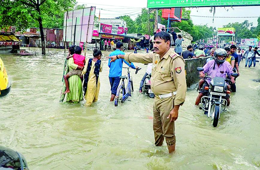
Recently, in Barabanki district (neighbouring Lucknow), on September 10 and 11, 2023, an unprecedented 400 mm of rainfall occurred in a span of 48 hours, marking the highest recorded rainfall for September in this region. This deluge triggered a flood-like situation in areas adjacent to the Reth river (a tributary of the Gomti stretching 109 km) and its tributary, the Jamuria (extending 22 km), as they traverse Barabanki district.
Beyond heavy rainfall, a significant contributing factor to the prolonged waterlogging in urban areas were the encroachments from unauthorized construction over the past decade along both banks of both rivers. These rivers are lesser-known and the authorities did not pay attention to the massive encroachment happening along their banks. There are hundreds of smaller rivers that are undergoing the onslaught of encroachment.
ENCROACHMENTS, LAWS
Urgent measures are required to safeguard these vital ecosystems and ensure the sustainable coexistence of rivers and humanity. Granting legal rights to rivers and their adjacent floodplains is imperative to ensure their preservation, especially in the face of regional development that has encroached upon their land. The Articles of the Constitution, provisions of various Acts and several policy documents provide the basic framework of legal rights of rivers. Various Acts, mandates and notifications have been issued by the Central and state governments from time to time to protect floodplains, reduce pollution and conserve watersheds in river catchment areas. But these provisions are scattered and seldom exercised in defending river rights.
To implement these provisions effectively, mutual coordination among all the concerned departments is required. However, models of effective coordination are missing.
In 2010, the Uttar Pradesh chief secretary issued directions to stop illegal construction/encroachment on river floodplains. The order also mentioned that the floodplain zone along the rivers should be displayed as a flood-affected area in the Master Plan, no construction was to be allowed and that land use should be kept green.
The National Disaster Management Authority (NDMA) in 2008 issued guidelines for states for flood zoning as an important “non-structural measure” to mitigate floods. It suggested that areas likely to be affected by floods in a frequency of 10 years should be reserved for green areas like parks and gardens and concrete structures should not be allowed. It also talks about other zones in the floodplain, for example, areas of flooding in a 25-year frequency, and asked states to make plans accordingly for those areas.
In 2016, the Centre also issued directions against encroachment on the floodplains of the Ganga or its tributaries. On July 13, 2017 in the M.C. Mehta vs. Union of India and others the National Green Tribunal (NGT) passed an order stating clearly that floodplains should be demarcated and “…100 meters from the edge of the river should be treated as no development/construction zone in segment-B of Phase-I, Haridwar to Unnao, Kanpur”.
In 2022, the chief secretary, UP government, directed the district magistrates of the state’s 75 districts to prepare and monitor revitalization and rejuvenation plans for smaller rivers and tributaries at the district level through the District Ganga Committee. A committee was also formed to identify government land/river area located within two km of small and tributary rivers and free it from encroachment.
The NGT was not satisfied with the response of the Ganga Committee regarding the encroachment. In November 2022, the Principal Bench of the NGT in an order stated that construction was to be removed by the Ganga Committee which had not been done and reiterated its order for the demolition of illegal structures.
SMALL RIVERS IMPEDED
Along with the gradual evolution of rivers in nature, water bodies came into existence through fluvial processes in the catchment areas. With time, the longitudinal and lateral connectivity of rivers and their water ecosystems got lost due to the development of roads, highways and residential colonies on the surface, but connectivity with the river remained through groundwater at the sub-surface level. The rivers and ponds on the surface have been fragmented and the existence of wetlands has been eliminated due to continuous encroachment, unplanned construction and change in their land use. In the past five decades, there has been irreparable loss of about 70 percent of wetlands in several districts of Uttar Pradesh.
Rivers generally move forward in the alluvial areas, meandering through vast landscapes. The natural flow of rivers is affected due to construction of bridges, highways and roads in the floodplain zone. Due to unplanned development of settlements without calculating the discharge of the river, the flow path and the alignment of a river changes.
It is often seen that bridges are constructed by the Public Works Department or National Highways Authority of India or other agencies without taking technical advice from the Irrigation and Water Resources Department, because of which the width and height of the bridge are hardly proximate to the design discharge of that site.
Due to poor design, the drainage is badly affected — resulting in severe waterlogging during the rains. As per the Environment (Protection) Act, 1986 and EIA Notification, 2006, proper assessment of environmental impacts must be carried out to ensure that no harm is done to the ecosystem, including rivers and wetlands.
Cities, having developed on the banks of rivers, are constantly expanding. Along with urbanization, industrialization is also happening rapidly. All man-made and industrial wastes from cities are discharged into rivers and their tributaries through natural drains. The smaller rivers are now considered nullahs, although they are natural units of all the rivers. Thus, rivers are no longer capable of purifying water and have become highly polluted. The Gazette Notification of the Ministry of Water Resources, River Development and Ganga Rejuvenation, dated October 7, 2016 states that “no person shall directly or indirectly discharge untreated or treated sewage or sewage sludge into the river Ganga or its tributaries or its banks”. However, the biggest polluters are the municipal agencies which are either discharging untreated sewage into the rivers or are unable to treat the sewage to required standards.
GROUNDWATER AND RIVER FLOW
Due to urbanization, groundwater has been exploited the most. Maintaining groundwater levels is essential as the underground water maintains the continuity of the water level of rivers and ponds during the dry season. Most of the rivers which do not originate in snow-covered mountains are fed by rainwater and their base flow primarily depends on groundwater and artesian wells. The decline in groundwater levels has resulted in drastic reduction in base flow, leading to the extinction of artesian wells.
All the natural water bodies and water sources in the catchment areas of the rivers will have to be revived so that groundwater levels can be recharged from these water bodies during the rainy season and minimum water flow can be ensured in the rivers due to the activation of artesian wells from groundwater during the non-monsoon period.
In 2019, the government came out with the Ground Water Management and Regulation Act, which talks about a water security plan and putting a limit on extraction. But the larger question remains — how will these provisions be implemented on the ground? Till date, no formula for sustainable extraction limits has been formulated. The Act is also silent on the biggest user of groundwater — the irrigation sector. The Act covers only bulk users in the urban and industrial sectors.
Often smaller streams, water sources and underground water in the watershed are defined as separate units whereas all of them are integral, indivisible and members of the river family. For the revival of the river, the water streams of its catchment area, its sources and underground water will have to be thought of as an integrated unit. All the units will have to be revitalized, only then is the revival and survival of rivers possible.
Rivers often traverse multiple jurisdictions, and coordination challenges between different districts can impede the effective implementation of rejuvenation plans. Based upon field observations, there seem to be large gaps in policy implementation, enforcement and monitoring by the district authorities, leading to non-compliance with orders designed to protect smaller rivers.
Venkatesh Dutta is a Gomti River Waterkeeper and a professor of environmental sciences at Ambedkar University, Lucknow.
Comments
Currently there are no Comments. Be first to write a comment!